Infrastructure and Instrumentation
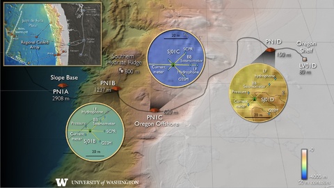
The Ocean Observatories Initiative (OOI) Regional Cabled Array (RCA) has been operational since 2015 and consists of two telecommunication cables extending offshore from Pacific City, Oregon. One crosses the Juan de Fuca plate to Axial Seamount (an undersea volcano located about 300 miles offshore) and the other extends into deep water (about 9500 feet) and then wraps back to the south onto the continental slope and shelf off Newport, Oregon. There are seven nodes along the cable that host a variety of instrumentation at small seafloor substations.
Off the coast of Oregon, the OOI RCA has four nodes: One at the slope base on the subducting Juan de Fuca plate, two on the continental slope, and one on the outer continental shelf. Long extension cables connect two more sites on the Southern Hydrate Ridge (SHR) and the Oregon shelf. The Oregon shelf site is located directly on top of one of two clusters of earthquakes offshore Oregon. Currently, geophysical instrumentation is limited to seismometers and seafloor pressure gauges at the slope base and SHR nodes.
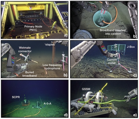
The COSZO project will add seafloor junction boxes connected by 200 meter cables to the nodes on the continental slope (PN1B, PN1C) and the continental shelf (PN1D), which will provide power and internet connectivity to a broadband seismometer, a strong motion accelerometer, a low frequency hydrophone, a differential pressure gauge, a seafloor pressure gauge, and an ocean current meter at each site. A broadband seismometer, accelerometer, and hydrophone will also be added to a preexisting seafloor junction box at the Oregon shelf site (MJ01C). Also, a Self-Calibrating Pressure Recorder (SCPR) will be installed at PN1B and PN1C and a Geodetic and Seismic Sensor Module (GSSM) will also be installed at all three continental node sites.
Science Junction Boxes connect to node sites along the RCA via a 200 meter long cable. They are equipped with ports to provide low-voltage power and real-time internet connectivity to scientific instruments. Instrument specifics: Designed and built by the UW Applied Physics Laboratory.
Broadband Seismometers and strong motion accelerometers collect three-component seismic velocity and strong-motion acceleration time series in real-time. They can be used to search for and localize shallow tremor signals and very low frequency earthquakes, accurately localize earthquakes below the continental shelf, measure temporal changes in the velocity structure of the accretionary prism, and facilitate offshore earthquake early warning research. Instrument specifics:
Low Frequency Hydrophone
Seafloor Pressure Gauge collects time-series of uncalibrated pressure to search for and remove artifacts of pressure calibrations that might be confused with slow slip and to support measurements of compliance that are sensitive to changes in seismic velocity structure.
Ocean Current Meter collects three-component ocean currents that can be used to constrain oceanographic pressure gradients, contributing to pressure geodesy, and contribute to an understanding of seismic noise that might be confused with tremor. Instrument specifics:
Self-Calibrating Pressure Recorder collects a time-series of calibrated pressure that can be used to measure secular vertical strain and detect slow slip events. It calibrates itself by utilizing a valve to periodically switch redundant pressure gauges from measuring ambient pressure to calibrate them against a piston gauge, a laboratory apparatus that generates a reference pressure. Instrument specifics: Designed and built by scientists and engineers at Scripps.
Geodetic and Seismic Sensor Module collects a time-series of calibrated pressure that can be used to measure secular vertical strain and detect slow slip events. It employs the A-0-A methods in which the reference pressure for calibrations is the internal housing pressure measured by an accurate barometer. It is a simpler instrument than the SCPR that includes a low-noise three-component quartz crystal accelerometer that can measure platform tilt and serves as a backup to the seismic sensors. Instrument specifics:


